Sunday, January 30, 2022

Hiking Shirts - January 31, 2022 -

 LAST CHANCE, HIKING CLUB SHIRTS  

Nellie informs me that she is going to complete the order for shirts and turn it in on Monday. We have to prepay so if there is anyone that has not paid or still wants a shirt, contact her at bobnelie@gmail.com or call her today at 780-940-5922 ! This will probably be the last time we order for two or three years. 


Thursday, January 27, 2022

January 28, 2022 - Saguaro National Park Long Hike - Kings Canyon to Wasson Peak. Medium Hike - Ridgeline. Short Hike - Casa Grande Mountain

Trailhead picture - Long and Medium Hike Group Picture


Long Hike to Wasson Peak


Petroglyph's 


Medium Hike to the Saddle


Friday's hike in Saquaro National Park in the Tucson Mountains will have both a medium and long hike and be loops. Both are moderate hikes that take you up one side of King's Canyon and down the opposite side, offer petroglyphs, an old mine and fantastic views of Tucson. The medium hike, led by John R, will be approximately 6 miles and go to a ridgeline that splits the Tucson Mountains east and west while the long hike, led by Tim, will be about 8 miles and go to the summit of the highest peak in the Tucson Mountains, Wasson Peak. From the ridgeline, the summit is visible and very much within your reach!

Directions: 

(GPS: Sonora Desert Museum) The trailhead is 0.1 miles from the museum entrance and across (north) the road. 

It is 65 miles from the park to the trailhead. Take I-10 south to exit 236 and turn right and then again right quickly onto  Marana Rd and proceed for one mile to North Sanders Road and turn left. After 4 miles turn left at the stop sign onto West Avra Valley Road and go one mile, where you turn right onto Sandario Rd. Proceed 11 miles and past the Saguaro Park entrance road to Mile Wide Road and turn left. Follow the signs for the Desert Museum. 

Short Hike:   Hike around the trails on Casa Grande Mountain with Denis. (His allergies are under control) His hike averages 3-4 miles and the group is usually back to Palm Creek by noon. This hike leaves from the central mailboxes at 8:00 a.m. on Fridays and hikers must have a Palm Creek Hiking Club Membership Waiver. Try to be at the mailboxes by 7:45 a.m.!

Upcoming Hikes:   

February 4, 2022, Peralta Trail (Both Medium and Long)

February 11, 2022, Romero Pools (To be determined)

Remember: 

If for some reason a hike must be canceled, you will receive an email by 6 a.m., Friday morning and you can go back to bed!

Jerry's Cell 307-630-0252

John's Cell 207-446-0650


Sunday, January 16, 2022

January 21th, Dynamite Trail at San Tan - Medium Hike. Short hike is Cancelled


Friday's Hike The Gold Mine, Dynamite and San Tan Trails Loop.  A hike to the peak on the Gold Mine Trail in the San Tan Regional Park near Queen Creek proves to be a good workout on the Gold Mine Trail and then continues to the Dynamite and San Tan Trails to complete a moderate loop hike of 6.5 miles. This hike offers many beautiful views of the San Tan Valley and along the way we view the graves of two prospectors that mined Gold Hill Mountain. There is a parking fee of $7.00 per vehicle. The trailhead offers plenty of parking, good restrooms, water and outside attractions to view. The drive is also shorter than most.


Directions: 

(GPS: San Tan Regional Park) Right turn out of Palm Creek and then a right turn at  Cottonwood. Then, do the same back road we've done before until you get to Hunt Highway. Here, turn left and continue on Hunt Hwy to North Vista Blvd. and turn left. There is a Walgreens on the corner. Continue to N Thompson Rd., turn left and drive to W Phillips Rd. Turn right and continue to the park. Remember we always caravan to the trailhead and your return trip is on your own.  

Upcoming Hikes:

January 28, 2022 - King's Canyon (Both Medium and Long Hikes)

February 4, 2022 - Peralta Trail (Both Medium and Long Hikes)

February 11, 2022 - Romero Pools ( Medium Hike)
Remember:  If for some reason a hike must be canceled, you will be emailed by 6 a.m. Friday morning!

Jerry's Cell 307-630-0252

John's Cell 207-446-0650  

Friday, January 14, 2022

January 14th, Long Hike, Fat Man's Pass from Dobbin Lookout, out and back (4.5 miles) Medium Hike, Fat Man's Pass from Overlook, out and back (8.1 miles) and Short Hike at Casa Grande Mountain (3-4 miles)


Medium and Long Hikers  - Group Pictures 


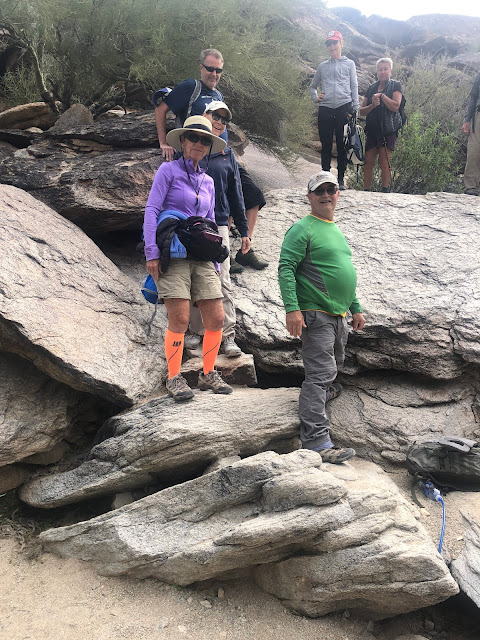
Long Hike:  Leader John  - Beginning at Dobbins Lookout


The Pass


Natural Tunnel


Medium Hike: Jerry Leader - Beginning at Buena Vista Parking lot 


Medium Hike Group and Long Hike Group had lunch together. 
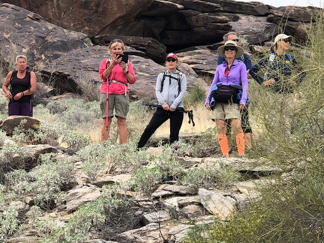


More Medium Hike 


The view of Pheonix 


Medium Hike: Fat Man's Pass  Approximately 4.5 miles

Hike the National Trail from the Buena Vista Lookout and the Hidden Valley Trail to Fat Man's Pass. For the most part, this is an easy hike with great views of the Phoenix area. The return trip is more uphill and steeper in parts but they are not too steep or very long. There are some interesting rock formations along the trail in addition to the tunnels and passes you navigate. 

Long Hike: Fat Man's Pass  8.1 miles

Hike from Dobbin's Lookout to Fat Man's Pass hiking the Holbert Trail, the National Trail and then the Hidden Valley Trail to Fat Man,s Pass.

Both the medium and long hikes offer fantastic views of the Phoenix area from South Mountain. Both offer Fat Man's Pass, a very narrow gap between rock faces that hikers must squeeze through ( There is a way around if necessary), another narrow gap where you slide under a rock face on a smooth rock, and a tunnel about 100 feet long. Washrooms are available for both groups at the gatehouse and Dobbin's Lookout.

Directions

Take I-10 north to exit 155, Baseline Rd. Go left on Baseline and proceed to Central Ave. Turn left on Central Ave. and follow it to the gate at the entrance to the park. Proceed on the paved road to Summit Road and at the top turn left for Dobbin's Lookout. The roads are well marked but narrow and twisting. A good GPS is Dobbin's Lookout 

Short Hike: Casa Grande Mountain 3-4 miles

A short hike around the trails on Casa Grande Mt. led by Denis and Reno. Their hike averages 3-4 miles and they are usually back to Palm Creek by noon. This hike leaves from the central mailboxes at 8:00 a.m. on Fridays and hikers must have a Palm Creek Hiking Club Waiver. Try to be sure to be at the mailboxes by 7:45 a.m. to secure waivers.

January Hikes 

January 21th, Dynamite Trail at San Tan. This is only a medium hike.

January 28th, King's Canyon. Both a medium and long hike.

Remember: If for some reason a hike must be cancelled, you will receive an email by 6 a.m., Friday morning so you can go back to bed!

Jerry's Cell  307-630-0252

John's Cell 207-446-0650